

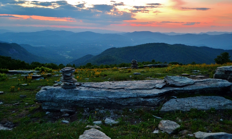
The grassy wide open summit is a perfect spot for a summer picnic or an evening hike to watch the sunset. Bearwallow Mountain is a beautiful spot in any season, but the wide open meadow with panoramic views of the surrounding Blue Ridge Mountains makes it a perfect spot to throw down a blanket, kick back and take it all in. The sprawling pasture-like setting is great for launching your kite or throwing around the frisbee too.

The parking area and trailhead is about 19 miles from Asheville and around 16 miles from Hendersonville. For those staying near by in Lake Lure and Chimney Rock, this makes a great day hike for families. The 4232 foot summit is only a 2 mile out and back hike up a twisting forest trail or you can take the easier option of the fire access road. We usually hike up the forest trail and return down the gravel fire road, especially in the twilight of sunset when its harder to see. I usually carry a small flashlight to help light the path, but on clear moonlit night you’ll be able to find your way with no problem. If your lucky enough, during the summer months you may be guided down the path by hundreds of fireflies.
The summit is home to a herd of grazing cattle during the summer, so dogs should be on a leash. Camping is not permitted here as the property is still privately owned, but protected and maintained by Conserving Carolina through a conservation easement. There is an unsightly collection of communications towers on the backside of the mountain’s summit, but they do little to affect the amazing mountain views. There is also an old fire lookout tower on the summit that was used by the Forest Service until the mid 1990’s to scout for forest fires.

The Bearwallow Mountain summit is the highest point in the area and is located on the western rim of the Hickory Nut Gorge. To the west you can see The Great Balsams and Mt. Pisgah. Looking towards the south you’ll see Hendersonville and areas down into South Carolina. Northerly views allow for panoramic views of the Black Mountains and Mt. Mitchell, the highest peak in the eastern U.S. at 6,683 feet.
Conserving Carolina secured 81 acres for protection in 2009 and is working to secure an additional 500 acres. The goal is for the trails on Bearwallow Mountain to eventually connect with the trail system in Hickory Nut Gorge and Chimney Rock State Park.

If you are interested in making your hike a little longer, consider exploring the Trombatore trail that starts from the same parking area. The trailhead is located on the opposite side of the road from Bearwallow. This strenuous 4.8 mile out and back trail winds up and down through a dense hardwood forest, passing by streams and eventually ending in a wide open pasture with panoramic views of the area.

Other Hikes in the area: Florence Nature Preserve trails, Little Bearwallow & Wildcat Rock, Chimney Rock State Park, Hickory Nut Gorge State Trail.

Directions:
Asheville Area: Take I-240 east 3 1/2 miles, continue straight on HWY 74A east. Follow 74A east for 12 1/2 miles. Turn right on Bearwallow Mountain Road. The road becomes gravel, gets steep and narrow, but cars shouldn’t have any trouble. Go 2 miles to the parking area on the left near old gate (road turns to pavement).
Lake Lure/Chimney Rock area:
From Lake Lure, it’s about 3.5 miles west on HWY 64/74A towards Bat Cave and where HWY 64 split. From the junction, go 5 miles West on 74A and turn left on Bearwallow Mountain Road.
Hendersonville area:
From HWY 64/I-26 interchange (exit 49) in Hendersonville, take HWY 64 east for 6.3 miles and turn left onto Mills Gap Road. Go 0.3 miles and turn right onto Bearwallow Road. Go 2.7 miles and turn left onto Clear Creek Road. Go just 0.2 miles and turn right, onto Bearwallow Mountain Road. Go 5 miles up to the parking area. Trailhead will be on the right at the gate.
“I haven’t been everywhere, but its on my list!”


