
I took a drive along a stretch of The Blue Ridge Parkway today to see how the fall color change was progressing. Thought I’d stop and do a quick hike up to the summit of Fryingpan Mountain, being its a short hike with a big reward at the top. This is a great way to get a panoramic ‘birds eye view’ of the Southern Appalachians. 
The hike to the summit is moderate and follows an old gravel fire access road(FR450) to the top. The road is rocky and washed out with areas of running water on the path from springs, so the appropriate footwear should be worn. The hike is only 1.5 miles roundtrip with about 500 feet of elevation gain, but features a steady continuous climb to the top.

The hike passes through dense forest and meadows with little opportunity for views until you reach the summit of Fryingpan Mountain at 5340 feet. The area is beautiful to visit in any season, but the autumn color change is pretty spectacular and the views are amazing. Spring and early summer sports a wide array of wildflowers and blueberry thickets along the hike to the tower. The summit is also a great spot to catch a sunrise or sunset and offers better views than the nearby(2.5 miles) Mt. Pisgah hike.


The historic steel fire tower was built by the Forest Service in 1941. At 70 feet tall, it is the tallest USFS lookout tower in Western North Carolina. It provided the perfect vantage point for decades to spot forest fires in The Pisgah National Forest. The 12′ X 12′ living quarters at the top is locked to visitors and hasn’t been used since the 1990’s. The site is now listed on The National Register of Historic places.


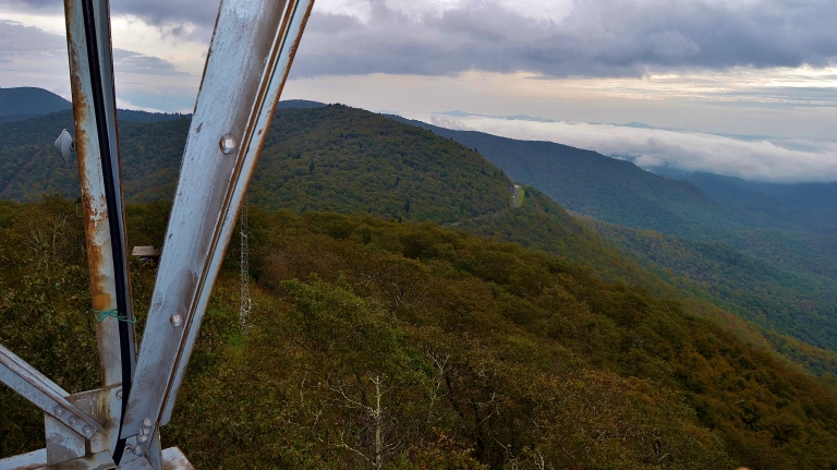
Once you’ve reached the top of the trail, you will find yourself staring up at the steep 5 stories of steps leading to the top of the tower. Those fearful of heights will certainly feel the pressure, as the stairs are narrow, steep and sway a bit as you climb. After a few flights up you begin to see only blue sky and feel the wind whipping as you become exposed. The first time I attempted the ascent, I only made it two flights before retreating to the bottom to regain my composure. I eventually made it to the top where you are rewarded with panoramic 360 degree views of the surrounding mountains. You can see Mt. Pisgah, Cold Mountain and The Shining Rock Wilderness, Looking Glass Rock and The Blue Ridge Parkway below.


Once you braved the climb, enjoy your expansive views of some of the 86,700 acres of The Pisgah National Forest. The trails here are in good shape in thanks to volunteers and donations from The Pisgah Conservancy.

The origin of the Fryingpan name is not clearly certain and several tales exist. Early pioneers in the area named a nearby pass Fryingpan Gap, so the mountain shares its namesake.

If you enjoy the views from up high on a lookout tower, consider visiting some of the others in the area: Wesser Bald Lookout Tower, Wayah Bald Lookout Tower, Rich Mountain Fire Tower or Green Knob Lookout Tower. All of these sites offer unparalleled views of the area.

This hike is pretty short in length, so you may want to consider doing one or two other hikes that are located near by:
- Graveyard Fields
- Mt. Pisgah
- The Pisgah Inn (for a drink or food)
- Skinny Dip Falls
- Black Balsam
Finding the trailhead and parking area is a little tricky and is often overlooked, as its not well marked. Coming south from Asheville the gated road and parking area will be on your right a couple miles after Mt. Pisgah. Coming from Brevard and Highway 276, the trail will be on your left after you go through the Fryingpan tunnel. Its right off the Blue Ridge Parkway at MP 409.6.


Leave No Trace – 7 Principles
- Plan ahead, Be prepared.
- Travel and camp on designated trails and surfaces.
- Dispose of waste. Pack in – Pack out.
- Leave what you find.
- Minimize campfire impacts.
- Respect wildlife – Flora and Fauna
- Be considerate to others


“A man on foot will see more, feel more & enjoy more in one mile than the motorized tourists can in a hundred miles.”

