

Trail leading to Wayah Bald Tower
Take a scenic drive through the Nantahala National Forest and visit the Wayah Bald Tower near Franklin, NC. This popular destination is located about 17 miles from downtown Franklin and will not disappoint with its amazing panoramic views of the surrounding mountains.


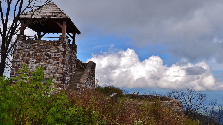
The old stone structure was built in 1937 by the Civilian Conservation Corps. The three story tower was originally used as a forest fire lookout until it was decommissioned in the 1940’s. In 2016 wildfires ravaged the area and burned the wooden roof off the lookout tower, but it was rebuilt in early 2018. The mountain top is still scarred with the remains of dead shrubs and trees, charred black by the intense fires. Green is returning to the area and soon it will be lush with vegetation once again.

The hike to the summit is only a 5 minute walk up a paved path from the parking area, so access is great for all ages and abilities. The Appalachian Trail and Bartram Trail both pass through the area if your looking for longer hiking options. Consider a 4 mile hike to another nearby tower at Wesser Bald along the Appalachian Trail.

On your drive up or down the mountain, consider stopping for a visit at the Wilson Lick Ranger Station. This historic cabin was built in 1916 and was one of the first stations in the area. There are information kiosks at the site to help you learn about the area back in the days of forestry.

The area near the parking lot is equipped with pit bathrooms and a picnic area. There is no water available, so plan on bringing enough with you for your visit. The road can be treacherous to travel in times of dense fog or inclement weather, so plan your trip ahead. The Wayah access road is closed down to traffic from January to March. The best time to visit the area is in the Spring when all of the Azaleas, Rhododendrons and wildflowers are in bloom(May & June).

Directions: From Franklin, North Carolina. Head west on US 64 for 3.7 miles and turn right at the sign for Wayah Bald, Old Murphy Road. From here take a quick left onto State Road 1310/Wayah Road. Go 9 miles to FR69 and turn right onto unpaved National Forest Road . Head up the winding mountain road for about 4.3 miles to the signed parking area for Wayah Bald. It’s 87 miles from Asheville.
“Do something that makes you feel small!”
Other Area Trails: Rufus Morgan Waterfall and Trail, Wesser Bald, Wine Spring Bald, Bartram Trail, Appalachian Trail


Thanks Todd, enjoyed the pictures and background information of the location. Driving directions is a plus and suggestion on time of year to visit.
Scott and Linda
LikeLike